
The Tropical Storm Isaias forecast is being closely watched as a tropical system develops over the Gulf of America. As of October 7, 2026, the National Hurricane Center is tracking Tropical Depression Nine, which is expected to strengthen into Tropical Storm Isaias and could become a hurricane later this week.
The system is currently over the southwestern Gulf, and forecasters expect it to move generally toward the northern Gulf Coast. The exact landfall location, timing, and strength can still change as the storm develops. People along the Gulf Coast should continue checking official forecasts instead of relying on an older track map.
This guide explains the Tropical Storm Isaias forecast, including its current location, expected path, possible strength, rainfall threat, wind risk, storm surge, areas that could be affected, and what residents should know.
Tropical Storm Isaias Forecast at a Glance
| Forecast Detail | Current Information |
| System | Tropical Depression Nine |
| Expected name | Isaias |
| Basin | Atlantic / Gulf of America |
| Current location | Southwestern Gulf |
| Current status | Tropical Depression |
| Current winds | About 35 mph |
| Expected development | Tropical Storm, then possible hurricane |
| General movement | East, then north/northeast |
| Potential U.S. impact | Northern Gulf Coast and Southeast |
| Main threats | Heavy rain, strong winds, coastal flooding, storm surge, tornadoes |
| Forecast confidence | Track and strength still uncertain |
| Forecast period | October 7–11, 2026 |
The National Hurricane Center reported that Tropical Depression Nine had maximum sustained winds near 35 mph and was moving east at about 5 mph in its latest available advisory. Forecasters expected strengthening, with tropical-storm strength possible early Wednesday and hurricane strength possible later Thursday.
Is Tropical Storm Isaias Forming Now?
Yes. The system currently being monitored as Tropical Depression Nine is expected to become Tropical Storm Isaias if it reaches the required tropical-storm wind threshold.
The National Hurricane Center said the depression was expected to strengthen quickly. If sustained winds reach at least 39 mph, it will receive the name Isaias.
The storm is developing over warm Gulf waters. Warm water can provide energy for tropical systems, although other atmospheric conditions, including wind shear, can limit strengthening.
Because the system is still developing, the forecast can change significantly during the next several advisories.
Read More:Jim Bakker: Biography, PTL Club, Scandal, Family, Career, and Death
Where Is Tropical Storm Isaias Right Now?
The developing system is in the southwestern Gulf of America, west of the northern Gulf Coast.
The latest National Hurricane Center information placed Tropical Depression Nine near 22.1°N and 95.0°W, with maximum sustained winds around 35 mph. It was moving east at about 5 mph.
Its position will change quickly over the coming days. Residents should use the latest official storm center information rather than relying on a static location from an older forecast.
Tropical Storm Isaias Track Forecast
The current forecast suggests that the system will initially move eastward before turning toward the north and northeast.
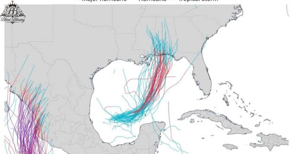
Forecast models show a range of possible paths. The storm could approach parts of the northern Gulf Coast from Louisiana toward the Florida Panhandle, with the exact landfall location still uncertain.
The uncertainty is normal for a developing tropical system. Small changes in the storm’s position, steering currents, and strength can produce a different track.
The latest forecasts indicate that impacts may extend well beyond the eventual center of circulation.
Could Isaias Become a Hurricane?
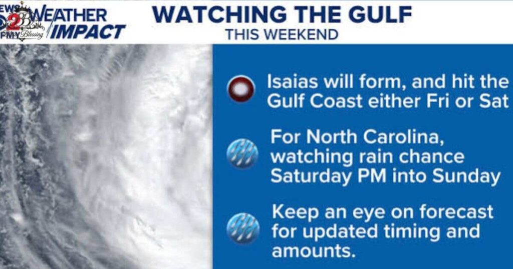
Yes. Current forecasts indicate that Isaias could strengthen into a hurricane.
The National Hurricane Center said Tropical Depression Nine was expected to become a tropical storm and could continue strengthening afterward. Weather forecasters are watching both warm Gulf waters and atmospheric wind shear because these factors could work in opposite directions.
Warm water provides energy for tropical development. Strong wind shear can disrupt the storm’s circulation and reduce its ability to strengthen.
Because these conditions can change, the final peak intensity remains uncertain.
When Could Isaias Become a Tropical Storm?
The current forecast calls for Tropical Depression Nine to strengthen into a tropical storm early Wednesday, October 7.
Once its sustained winds reach 39 mph or higher, the storm will officially receive the name Isaias.
Forecasters are also watching for additional strengthening later Thursday.
When Could Isaias Reach the Gulf Coast?
The current forecast places the greatest concern toward the end of the week and into the weekend.
Weather forecasts indicate that the system could approach the northern Gulf Coast by Friday or Saturday. The exact timing depends on how quickly the storm strengthens and how its steering pattern develops.
Even a relatively small change in forward speed could shift the arrival time of strong winds and heavy rain.
Which States Could Be Affected?
The areas with the greatest potential concern currently include parts of:
- Louisiana
- Mississippi
- Alabama
- Florida
- Georgia
- Tennessee
- Other parts of the Southeast
The exact impact area will depend on the final track.
The storm’s rainfall could spread much farther inland than its strongest winds. Forecast information indicates that heavy rain could move through portions of the Southeast and farther inland during the weekend.
Louisiana and Mississippi Forecast
Louisiana and Mississippi are among the areas being closely monitored.
The National Weather Service in New Orleans/Baton Rouge said tropical development was expected in the southern Gulf and warned of possible gusty winds, coastal flooding, heavy rainfall, and higher waves and seas.
The exact impacts will depend on the storm’s eventual path.
People near the Louisiana and Mississippi coasts should monitor local emergency-management instructions and updated National Weather Service forecasts.
Florida Panhandle Forecast
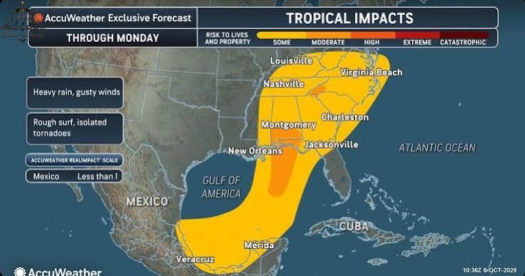
The Florida Panhandle is also within the broad area that could experience impacts.
Current forecast information suggests the storm could approach anywhere from Louisiana toward the Florida Panhandle. This means the final track remains important for determining which communities receive the strongest winds and heaviest rainfall.
Even if the center does not make landfall in Florida, outer rainbands and coastal effects could still reach parts of the state.
Texas Forecast
The current forecast does not indicate a direct landfall threat for much of Southeast Texas.
The National Weather Service office in Houston/Galveston said the system was expected to remain well east of Southeast Texas, although some indirect effects could still occur. Hazardous marine conditions were expected to become more likely later in the week.
Residents should still check local forecasts because tropical systems can change direction.
Rainfall Forecast
Heavy rain is expected to be one of the major threats from Isaias.
Current forecasts indicate that rainfall could begin affecting the Gulf Coast as early as Friday before spreading inland through the Southeast over the weekend. Some locations could receive several inches of rain, with locally higher totals possible.
Heavy rainfall can cause flash flooding even when a tropical cyclone is not especially strong.
Low-lying areas, locations near rivers and streams, and places with poor drainage can be particularly vulnerable.
Flooding Threat
Flooding may become one of the most important hazards associated with Isaias.
Heavy tropical rainfall can overwhelm drainage systems and cause rapid rises in creeks and streams.
The potential flooding area could extend well beyond the storm’s center. This is why people should not assume they are safe simply because the forecast cone does not pass directly over their community.
Never drive through a flooded roadway. Water can hide damaged roads, debris, or strong currents.
Wind Forecast
Wind strength will depend heavily on how much the system strengthens before reaching land.
If Isaias becomes a hurricane, hurricane-force winds could affect a smaller area near the center, while tropical-storm-force winds could extend farther outward.
Strong winds can bring down trees, damage roofs, break branches, and cause power outages.
Residents in areas under watches or warnings should complete preparations before the strongest winds arrive.
Storm Surge and Coastal Flooding
Coastal flooding is another concern.
A tropical cyclone can push seawater toward the coast, causing water levels to rise above normal tides. The amount of storm surge depends on storm strength, size, track, coastal shape, tides, and other factors.
Current local forecasts are still developing, so specific storm-surge numbers may change.
People living in vulnerable coastal areas should pay attention to official evacuation instructions.
Could Isaias Produce Tornadoes?
Yes, tropical systems can produce tornadoes, particularly in their rainbands.
The risk is often greatest in areas east or northeast of a tropical cyclone’s center, depending on the storm’s structure and surrounding atmospheric conditions.
If Isaias approaches the Gulf Coast and then moves inland, isolated tornadoes could become a concern in parts of the Southeast.
Residents should have multiple ways to receive weather warnings, especially overnight.
Isaias Forecast and Wind Shear
Wind shear is an important factor in the intensity forecast.
Strong wind shear can tilt a tropical cyclone and disrupt its circulation. Lower wind shear can give a developing storm a better environment for strengthening.
Current forecasts suggest Isaias could encounter increasing wind shear as it moves north. That could limit some of its strengthening closer to land.
This is one reason the forecast intensity can change from one advisory to another.
Why the Isaias Forecast Can Change
Tropical cyclone forecasts are updated frequently because the atmosphere is constantly changing.
Forecasters must evaluate:
- Storm location
- Steering currents
- Ocean temperatures
- Wind shear
- Atmospheric moisture
- Pressure patterns
- Forward speed
- Storm structure
- Interaction with land
A small change in any of these factors can affect the predicted track or intensity.
That is why the latest National Hurricane Center advisory is more useful than a forecast published several days earlier.
Tropical Storm Isaias Forecast Cone
The forecast cone shows the probable track of the center of a tropical cyclone.
It does not mean that areas outside the cone will avoid dangerous weather.
Rain, wind, tornadoes, and coastal flooding can extend far away from the center. The cone also does not show the full size of the storm.
For this reason, people should focus on local watches, warnings, rainfall forecasts, wind probabilities, and emergency instructions rather than looking only at the center line.
The National Hurricane Center provides official forecast-cone and wind-probability products for active tropical systems.
What Should Residents Do Now?
People potentially affected by Isaias should prepare before the storm becomes stronger.
Useful steps include:
- Check the latest local forecast.
- Charge phones and backup batteries.
- Keep important medications accessible.
- Secure loose outdoor objects.
- Bring in patio furniture and decorations.
- Check flashlights and batteries.
- Keep emergency supplies ready.
- Protect important documents.
- Know your evacuation zone.
- Review your family’s emergency plan.
- Avoid unnecessary coastal travel during the storm.
- Never drive through floodwater.
Preparation is easier before strong winds and heavy rain arrive.
Isaias Forecast for the Weekend
The weekend is currently an important period in the forecast.
The storm is expected to approach the Gulf Coast around Friday or Saturday and then move inland across the Southeast. Heavy rain could continue well after landfall as the system moves inland.
Because the track is not yet locked in, people should avoid treating any single model prediction as a guaranteed outcome.
Is Tropical Storm Isaias the Same as the 2020 Storm?
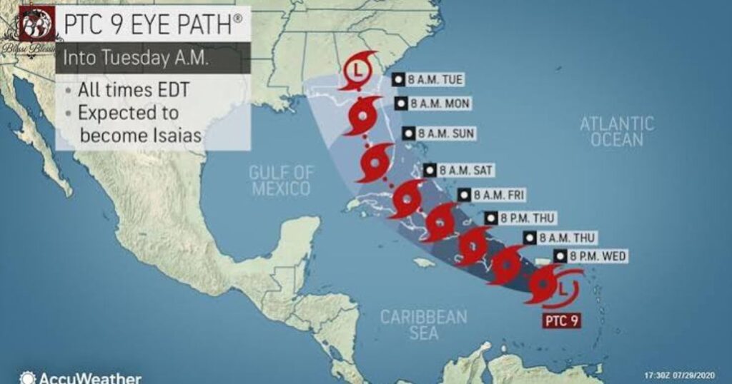
No. The 2026 Isaias is a different storm from Tropical Storm Isaias of 2020.
The name Isaias was previously used for a major Atlantic storm in 2020. That storm affected the Caribbean, Florida, the U.S. East Coast, and other areas before moving into Canada.
The 2020 storm is now part of hurricane-season history, while the 2026 system is a new tropical cyclone using the name again.
This distinction is important because online searches for “Tropical Storm Isaias forecast” can return older 2020 forecast maps and articles.
What Happened to Isaias in 2020?
The 2020 Tropical Storm Isaias became a hurricane during its lifetime and affected parts of the Caribbean and the U.S. East Coast.
An August 1, 2020, National Hurricane Center advisory showed Isaias approaching southeast Florida with maximum sustained winds of 70 mph. The forecast at that time called for the storm to move near or along Florida’s east coast before continuing toward Georgia and the mid-Atlantic.
The 2020 storm also produced heavy rainfall, flooding, strong winds, and dangerous surf conditions across several areas.
Those historical impacts should not be confused with the developing 2026 system.
Tropical Storm Isaias vs. 2020 Isaias
| Detail | 2026 Isaias | 2020 Isaias |
| Year | 2026 | 2020 |
| Current status | Developing | Historical storm |
| Starting area | Gulf of America | Atlantic/Caribbean |
| Main current concern | Northern Gulf Coast | U.S. East Coast and Caribbean |
| Forecast type | Current and changing | Historical |
| Same storm? | No | No |
What Does the Name Isaias Mean?
Isaias is the Spanish form of the biblical name Isaiah.
The World Meteorological Organization uses predetermined naming lists for Atlantic tropical cyclones. Names are assigned to tropical storms when they reach the required strength.
Using the same name in different years does not mean it is the same storm.
Tropical Storm Isaias Forecast: What to Watch Next
The next several National Hurricane Center advisories will be important.
Forecasters will watch:
- How quickly the depression strengthens
- Whether it becomes Tropical Storm Isaias
- Whether it reaches hurricane strength
- How far north the center turns
- The eventual Gulf Coast landfall location
- Rainfall totals
- Storm-surge potential
- Wind probabilities
- Tornado potential
- How quickly the system moves inland
These details will become clearer as more observations and forecast-model data become available.
Frequently Asked Questions About Tropical Storm Isaias Forecast
Is Tropical Storm Isaias forming in 2026?
Yes. Tropical Depression Nine is expected to strengthen into Tropical Storm Isaias. The National Hurricane Center is forecasting continued strengthening.
Is Isaias expected to become a hurricane?
Current forecasts indicate that the system could become a hurricane later this week. The exact peak strength remains uncertain because atmospheric conditions can change.
Where is Isaias expected to make landfall?
The exact landfall location is not yet certain. Current forecast information shows a possible approach somewhere along the northern Gulf Coast, broadly from Louisiana toward the Florida Panhandle.
When will Isaias reach the Gulf Coast?
Current forecasts suggest the storm could approach the Gulf Coast around Friday or Saturday, October 9–10, 2026. The timing may change as the forecast is updated.
What states could be affected by Isaias?
Potentially affected areas include parts of Louisiana, Mississippi, Alabama, Florida, Georgia, and other parts of the Southeast. The final impact area depends on the storm’s track.
What is the biggest threat from Isaias?
Heavy rainfall and flooding are major concerns. Strong winds, coastal flooding, storm surge, and isolated tornadoes are also possible depending on the final track and strength.
Is Isaias the same storm from 2020?
No. The 2026 system is a new storm. The name Isaias was also used for an Atlantic storm in 2020.
Where can I get the latest Isaias forecast?
The National Hurricane Center is the primary official source for Atlantic tropical cyclone forecasts, advisories, forecast tracks, wind probabilities, and warnings.
Conclusion
The Tropical Storm Isaias forecast is still changing as Tropical Depression Nine develops over the Gulf of America. Current forecasts indicate that the system should strengthen into Isaias and could potentially become a hurricane before approaching the northern Gulf Coast.
The most important threats include heavy rainfall, flooding, strong winds, coastal flooding, storm surge, and possible tornadoes. The exact location and severity of these impacts will depend on the storm’s final track and intensity.
Residents along the Gulf Coast and across the Southeast should continue monitoring official forecasts. Because tropical systems can change quickly, the latest National Hurricane Center and local National Weather Service updates should be used for decisions about travel, preparations, watches, warnings, and evacuations.

